Archive

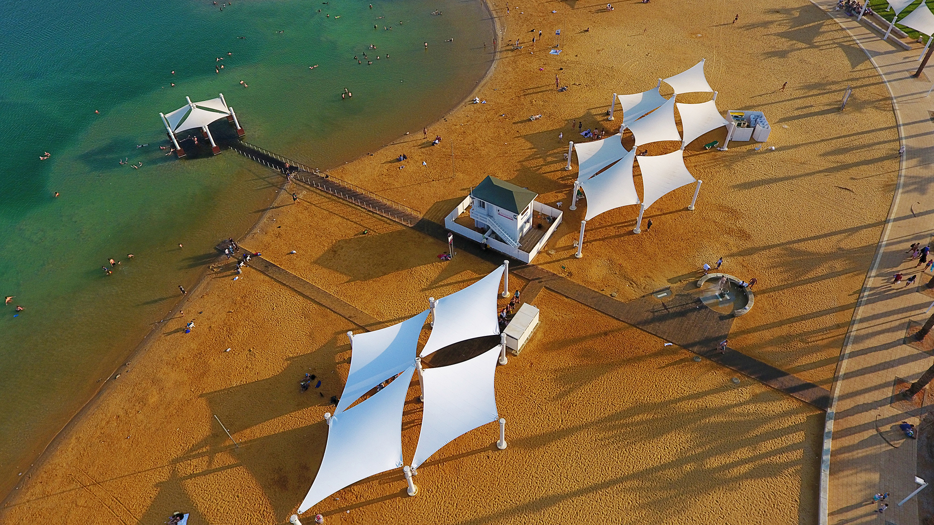
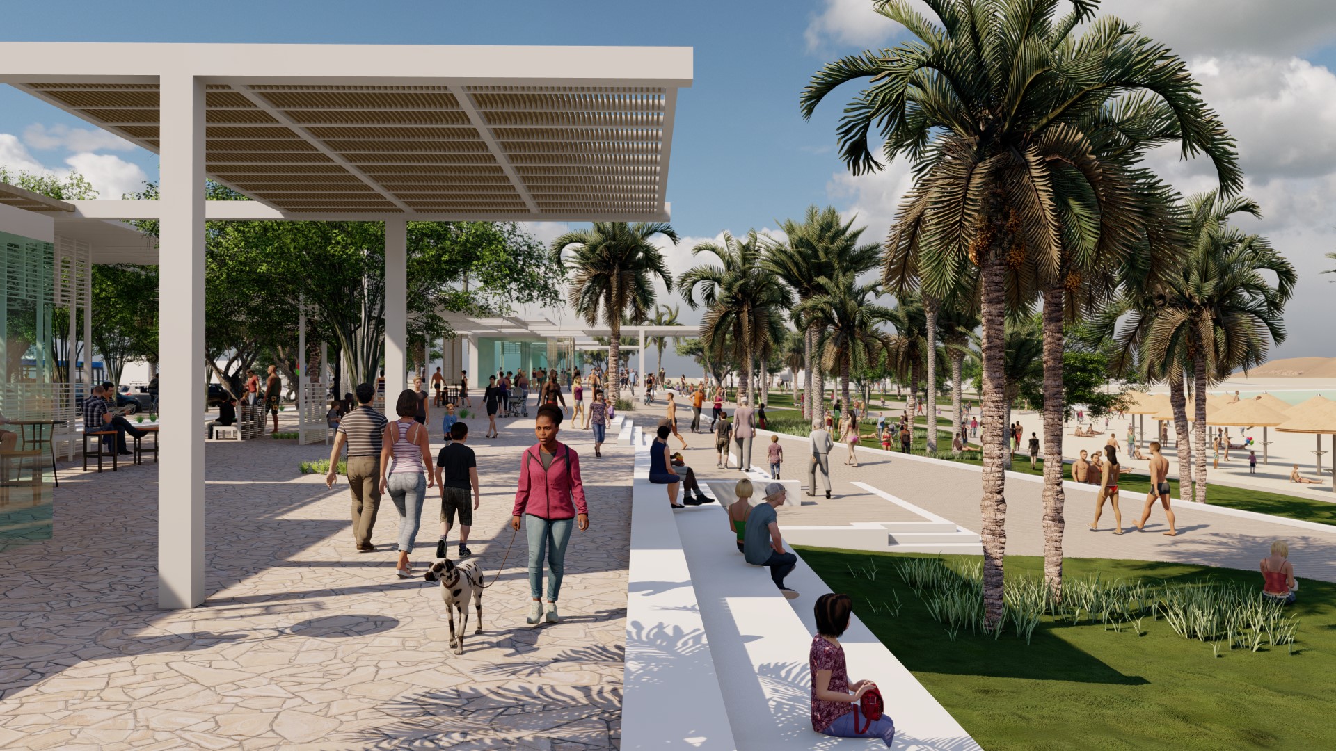
The Eastern Lagoon Promenade, Eilat

The Eastern Lagoon Promenade is part of a new tourist area around an artificial lagoon. The plan allows for the construction of ten hotels and vacation residences as well as a number of public building programs. Our office started out preparing the marketing portfolio for the entire site, which includes the design guidelines for all building plots and public open spaces. The latter includes five new public beaches, two large parks and several small parks, promenades, streets and more. The development of the entire plan is being advanced in stages, with the main streets in the west and some of the hotel lots now under construction. The Eastern Lagoon promenade, the adjacent park and beaches are presently in the planning phase. This area will be developed as an intensive urban axis with a variety of restaurants and cafes with play and leisure areas between the beach and the promenade. Special importance is given to the amount of shade in the project by significant planting of trees and the construction of large pergolas. In addition to the hotels, the plan will add a new waterfront area to the city of Eilat that will be used not only by tourists but also by the city's residents, who will benefit from a significant increase in the number of public beaches and the addition of large open public areas with good access to public transportation and bicycle paths....

Wine Park, Ashkelon

The 60-hectare Wine Park is located in a wide topographic depression in the northern part of the port town of Ashkelon, bordered by the existing Barnea neighborhood and the new 'Wine City' development presently under construction. What gave the park its name is the large archaeological site with findings dating from 2000 BC, reaching its peak in the Byzantine period. The ancient ​​4-hectare-large agricultural estate was discovered by chance in the 1990s as a result of illegal sand mining. The excavations revealed grape pressing houses, storage facilities, a textile house, and a workshop producing the amphoras in which wine was exported across the Mediterranean Sea. A Roman-era milestone was found in the area, suggesting that the 'Via Maris', the main coastal trading route during the Roman period, had passed through the site. The site analysis revealed a wealth of additional existing landscape features: a seasonal river, sandy slopes covered by natural vegetation interspersed with mature sycamore trees, agricultural fields and citrus orchards, a former tree nursery with palm groves and orchards, and small winter ponds. The design concept for the park emerged as part of the existing landscape values and around the theme of the archaeological site. The existing grid of agricultural orchards and fields informed the formal concept for the park. The plan creates a tapestry of agricultural fields and orchards of different kinds, interspersed with "rooms" housing various programs. Some rooms are large and intended for city -wide programs, such as an open-air performance area, a skateboard park and playground areas; others are hidden and quiet, such as a butterfly garden and outdoor classrooms overlooking the stream. Restaurants, sports and play facilities, and picnic areas complete the program. Two main systems of paths traverse the site: a central axis referencing the path of the ancient Via Maris that passes through the archaeological site; and a pedestrian walkway and bicycle path that meanders throughout the site and connects visitors to the many points of interest. A network of additional paths provides full access to the surroundings neighborhoods. The planning includes the ecological restoration of the stream bed with gently sloped grass areas to the west providing both access to the water and areas for temporary flooding during heavy rain events. Pedestrian bridges will connect the Wine Park to the new neighborhood's system of linear parks....

Crater Park, Givataim

The redesign of a former football stadium into a neighborhood park with new housing and commerce resurrected the site as the new active center of the entire neighborhood. The site of Crater Park and two new residential towers is defined by very steep slopes and a long-lasting public debate about what should happen to the historic 'crater' of Givataim. The project replaces a football stadium and amphitheater excavated in the 1920s, which were a neighborhood symbol and a source of pride but suffered from underuse and neglect. A new zoning plan from 2003 outlined the new division of the site: residential towers in the upper third of the site allowing for free public passage to the lower two thirds designated for park use. A small commercial center and a Kindergarten form the lower edge of the park. The concept for the park was to create a green and active neighborhood park with multiple points of interest for residents of all ages, all this while providing universal access to all areas. Steep slopes (14% - 11%) with an overall height difference of 17 m made it difficult to provide full accessibility between all parts of the park: creating a fully accessible system with hundreds of meters of ramps would have taken up most of the site. The solution was to divide the park into three main levels with multiple access points from the surrounding streets and stairs connecting between them. The upper level consists of gardened areas around the residential towers with a plaza leading to a dramatic view terrace, and the park beyond. The middle level forms the heart of the park and includes a variety of play structures and fitness equipment, observation and rest areas and an ecological pond. Grassy slopes between different activity areas invite people to find quiet places in the shade of trees and reduce the need for walls and fences .The lowest level connects to the outdoor sitting spaces of the commercial center and includes a small amphitheater around an additional playground area and an enclosed dog park. All parts of the redevelopment come together to form the new center and meeting place for the residents of the entire neighborhood....

Light Sculpture Plaza

The city asked to create a strong focal point at the end of the central spine of the new city center development. The new plaza became an instant meeting place for old and young, who discover the many different angles of the colorful sculpture while enjoying the play of light and shadows throughout the day and at night. The light sculpture provides a landmark and destination point for visitors, but also a transition between the quiet and green of the existing linear park and the intensity and activity of the new city center. In the daytime, the sculpture defines grassy and paved outdoor rooms for visitors to meet and sit in and creates an experience of shifting colors for those passing around and through.  At night, the sculpture is lit up dramatically, projecting patterns of light and shadow. Young people from the surrounding neighborhoods and visitors to the area enjoy gathering in the striking world created within the sculpture. The sculpture is composed of identical steel elements, placed at varied angles and spacings to form three arched waves.  The sides of the elements in each wave are painted with three of four total colors, thus creating the shifting color impressions for visitors as they move around the space.  ...

Fountain Plaza

This new plaza at the main entrance to Modiin welcomes residents and newcomers alike to the city: the dramatic water gates of the fountain, placed on the background of a large vertical green wall, create a strong visual focal point but also provide the city's children with an exhilarating opportunity to cool themselves off in the hot summer months. The office was asked to design a signature water fountain at the entrance to the city, a real challenge considering the small size of the site and its location at two busy intersecting roads. Our goal was to create a lively urban plaza with a water feature of strong visual presence while making it pleasurable and usable for the residents.  The central fountain square features seven water curtains which dare everybody to pass through them. An adjacent sitting area shaded by Plane trees offers a quieter corner to read a book, enjoy the sparkling lights of the waterfalls or to marvel at the many different plants of the green wall....

Eco Park, Ashkelon

Eco Park is designed as a contemporary and ecological city park which preserves the natural resources and ecosystems of the site while linking it to the city's vision of creating an active urban park that serves as a center for sports and recreation. The park is part of an ecological corridor stretching from east to west, which comprises sand dunes to the south and an extensive flood basin and seasonal winter pond to the north. The winter pond is an essential part of the natural drainage system of the southern part of the city, which suffers from severe flooding problems. The project applies landscape and engineering solutions to channel the runoff water into both bodies of water. The park's plan is based on the relationship between two bodies of water - the natural winter pond and a new recreational lake. The winter pond is the heart of the natural park area. Observation pergolas, bird watching stations, and outdoor classrooms in nature are planned for construction beside the pond.  The recreational lake contains two islands and is surrounded by a rich variety of water plants. All intensive park uses are concentrated around the recreational lake, including a center for boat rental, playgrounds, lawns, picnic areas, geodesic domes that serve as classrooms, and a small amphitheater.  A system of walking and bicycling paths weaves both areas together while allowing for differentiated access to the more quiet and active park areas....

The New City Center of Modiin

The central spine of Modiin's new mixed-use city center provides an exciting and identifiable destination for its residents, with points of interest to be enjoyed by all ages and at all times of the day. The overall concept for Modiin's new city center (based on Moshe Safdie Architects' statutory plan) envisions the creation of a unique and vibrant mixed-use central business district along a central green spine, inviting people to discover urban living and shopping, and to enjoy the open spaces of the new civic heart of the city. The landscape design puts pedestrians and bicyclists first, providing a generous and secure environment to shop, stroll, play, or rest.  Four rows of Plane and Jacaranda trees form the green structure of the boulevard. The design of the linear promenade in the center includes water features, shade structures, sitting areas, and five restaurants/coffee shops. The promenade is framed by lush plantings, which act as rain gardens in the winter months while providing optimal growing conditions for the trees. Along the sidewalks, continuous planting strips for trees and groundcovers form a green buffer between pedestrians and bicyclists while collecting run-off in the rainy season....

Arazim Valley – Utilities Park

The Arazim Valley, located north of Highway 1 at the western entrance to Jerusalem, is part of the city's metropolitan park system, Jerusalem Park. The valley is a breeding and nesting habitat for a variety of plant and animal species.  At the same time, because the Arazim Valley is a large open area west of the city, it is also a desirable corridor for the passage of urban and national infrastructure. Throughout the valley, an attempt was made to hide and camouflage the infrastructure passing through. The theme of "Utilities Park" is, instead, to present the subject of infrastructure and explain it to visitors. The park is centrally located in the valley on the southern bank of the Sorek River. The works included rehabilitation of the riverbed and of the terraces along its banks, extensive plantings of trees, shrubs, and geophytes typical of the area, and construction of public areas including: a promenade, play facilities for children and toddlers, lawn, and shaded picnic areas. Two bridges, built above the streambed, connect the park to the paved bicycle path on the northern bank of Nahal Sorek and onwards through the entire valley. One bridge is an “extreme rope bridge”, which is an integral part of the playground facilities, while the other is an accessible wood and steel bridge allowing the passage of cyclists, strollers and wheelchairs....

Suzanne Delal Dance and Theater Center

As the core project for the rejuvenation of a historic neighborhood of Tel Aviv, a 2,800 square meter plaza was created between two abandoned schools by closing the road between them. The school buildings themselves were renovated to become a large modern theater and a dance school. The new urban plaza between these buildings facilitates many related activities, as well as providing a large urban public open space in the neighborhood. The singular use of orange and citrus trees in the plaza reminds visitors of the orange groves that were originally planted here. Small water runnels around the trees, falling down one step, create a welcome sense of relief in the heat of summer. Urban formality is mixed here with historic reminders....

Dead Sea Promenade, Ein Bokek

While sea levels in the northern portion of the Dead Sea are dropping drastically each year, this project was initiated in response to the problem of rising sea levels in the southern portion caused by industrial mining activity. The design creates an integrating, continuous public space connecting the main axis of hotels with the raised and renovated beach and new promenade along the seashore.  The project is organized as a series of zones moving outwards from the sea: beach, promenade, beach park, parking, and finally the main axis of hotels and transport, all of which are framed by the striking desert cliffs. The beach zone penetrates into the sea itself with accessible decks to bring bathers into the water.  A series of large shade structures protect visitors from the average summer temperatures of 40 degree, providing large islands of continuous shade designed for families and to encourage groups and interactions between the diverse visitors.  The white of the shade sails offsets the warm colors of the desert landscape and the brilliant blues of the sea, and the silhouette of the structures creates a dialogue with the Jordanian Hills at the horizon. The beach park is planted with a grid of date palms which evoke the typical agricultural groves of the Dead Sea area and which provide a strong vertical architecture and sense of scale. The park includes lawn for picnicking families, as well as desert plantings, and is watered with treated wastewater from the hotels....

Fish Park, Modi’in

The 'Fish' park is one of the central open spaces in the new town of Modiin, connecting two linear parks on its edges. Central to the design were the preservation of the long views across its long axis while providing a maximum of play structures and facilities for this new and young community. The collaboration with the Israeli artist Aaron Ben-Arieh produced a series of play "stations" under the overall motive of "Fishes and Sealife". A large pergola provides much needed shade, overlooking grass terraces for informal ball games....

Glil Yam Park

Glil Yam Park is a large area of about 200 dunams in Herzliya, north of Kibbutz Galil Yam, framed by new residential neighborhoods. In addition to leisure and community uses, the park is unique in that it includes the diversion of the Glilot Stream and the creation of extensive areas within the park for stormwater detention. The program required detention areas for about 35,000 cubic meters of water, leading to a dramatic topographical design. The stream runs through the center of the green area, creating a series of large pools with grassy slopes. During rainfall events, the stream's water fills the pools and prevents flooding of the nearby train station. After a few days, the water seeps into the groundwater. The rainy winters since the park opened to the public have highlighted the challenge of managing peak rainwater systems. The detention system has worked successfully, creating beautiful pools for the enjoyment of residents. The site exemplifies a successful attempt to address peak rainwater systems by detaining stormwater in open spaces within urban areas and proves that it is possible to harness detention to enhance active open space in the city. The paths and active areas in the park are located on the higher margins on both sides of the stream, interwoven with play areas, unique shading structures, a challenging bike path, fitness facilities, and food zones. A wide pedestrian bridge connects the two parts of the park, with a gentle ascent that blends into the landscape. At this point, a water reservoir with a diameter of 50 meters is discreetly integrated in the topography for city use. A café has been built on the side of the reservoir, facing the active areas and enriching the space....

Herzelia Park

The park in Herzliya is a work in progress with less than half of the entire park developed: the Master Plan envisions the protection and further enhancement of the existing water systems, while providing new recreational facilities for the inhabitants of Herzliya and the region. It is being implemented and adjusted in a dynamic process of public participation and education, on-site research about the site's unique natural processes and assets, and an on-going understanding on our part of what the expectations and needs in a modern urban park are. The park is located on an historical flood plain with large seasonal winter ponds. The existing matrix of the drainage and flooding systems, combined with the idea of using the imagery of a tree with extending branches as the organizational structure, determined the formal language for the park: the general layout and the design of its built elements interprets this basic idea of 'natural flow'. The first stage included re-habilitated drainage channels, a lake, and an amphitheater, a feature playground area and a coffee shop/public facilities building. Separate path systems for runners and cyclists weave through the park and connect to the existing surroundings. The following stages were designed around the unique winter ponds with their rich wildlife of migrating birds, including viewing decks and bird watching shelters while continuing the basic structure of pedestrian, bicycle and running paths, as well as play areas....

Park of the Groves

"Park of the Groves", the largest green space in South Tel Aviv at 100 acres, has undergone a series of changes over the last century. Remnants of elevated irrigation pools and well houses, found today inside large groves of oak and pine trees, recall the traditional agriculture of citrus groves once cultivated by Arab farmers from Jaffa. Based on the city's Master Plan, the design of the first stage defined several strategic intentions:  improving connectivity throughout the site and with its surroundings; exposing and integrating the various historical layers in the design; creating a sustainable green space with emphasis on existing urban ecologies; inserting of recreational activities; using mainly standard municipal details in order to ensure easy maintainability while concentrating resources on special features. Foot and bicycle paths traverse the park and connect it to the city beyond.  Along the now pedestrian-only axis of Ofer Cohen Street, a series of plazas and an amphitheater provide a platform for events and local initiatives. Replanted orchards around the three historical irrigation pools and the reconstructed traditional irrigation system bring alive the agricultural landscape of the past.  A large play area and viewing tower create a major attraction for children, while an herb garden in the shade of existing fruit trees offers a pleasant area for visitors who seek quiet. All new plantings in the park are of agricultural or indigenous species, encouraging an increase of wildlife, including an ecological pond with a bird watching shelter. Many areas are left to naturalize with minimal maintenance.  Most of the rain water runoff is captured on site by creating low-point basins and terracing of the existing topography, allowing for water return to the aquifer....

Sapir Park

In the 1980's, engineers building the desert settlement of Sapir were surprised to find water seeping through new foundations.  Geological analysis in the area showed a layer of clay capping a permeable layer of fractured dolomite stone. It was decided to drain and collect the water away from the settlement by creating a small lake. By removing alluvial debris and the clay layer, water was allowed to percolate into a pool of about 3,000 square meters.  The sides of the basin were lined with concrete topped with river-washed local stone; the bottom was left unlined to allow the upwelling of water.  The area of the lake was determined by the amount of groundwater seeping through the permeable strata minus the rate of evaporation throughout the year. The water level remains constant through the balance of these quantities. Sapir lake has been developed into a desert oasis for recreation. It has a boardwalk at one end from which people fish.  There is a re-circulating rivulet which adds a pleasant background sound, and grassy banks where people can picnic and play....

Gabriel Sherover Promenade

This promenade overlooks the Old City of Jerusalem, parts of western Jerusalem and a great sweep of the Judean Desert. Its 1,350 meter long walk is used by both Jews and Arabs as well as tourists and pilgrims to Jerusalem. Its quiet gardens, planted with agricultural species such as wheat and olives, and its many viewing pergolas, create an atmosphere of peace and beauty in which to enjoy this unique and world-famous site. The garden contrasts sharply with the desert which begins immediately at its feet, and provides an elegant transition from the city to the classic views of Jerusalem....

South Beach Promenade, Eilat

This one-kilometer-long Promenade, located on the western edge of Coral Beach Nature Reserve, provides a pleasant route for tourists and residents walking or bicycling at the edge of the Red Sea. Wood is used extensively for edges, steps and pergolas, while local granite is the major paving for the paths.  Granite boulders punctuate the way, creating a focus for desert planting. Crushed local granite is used extensively as a surface cover between the planting areas, making a connection to the surrounding mountains.  ...