Archive

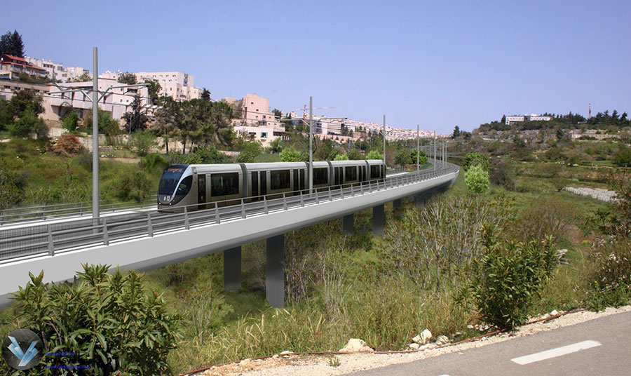
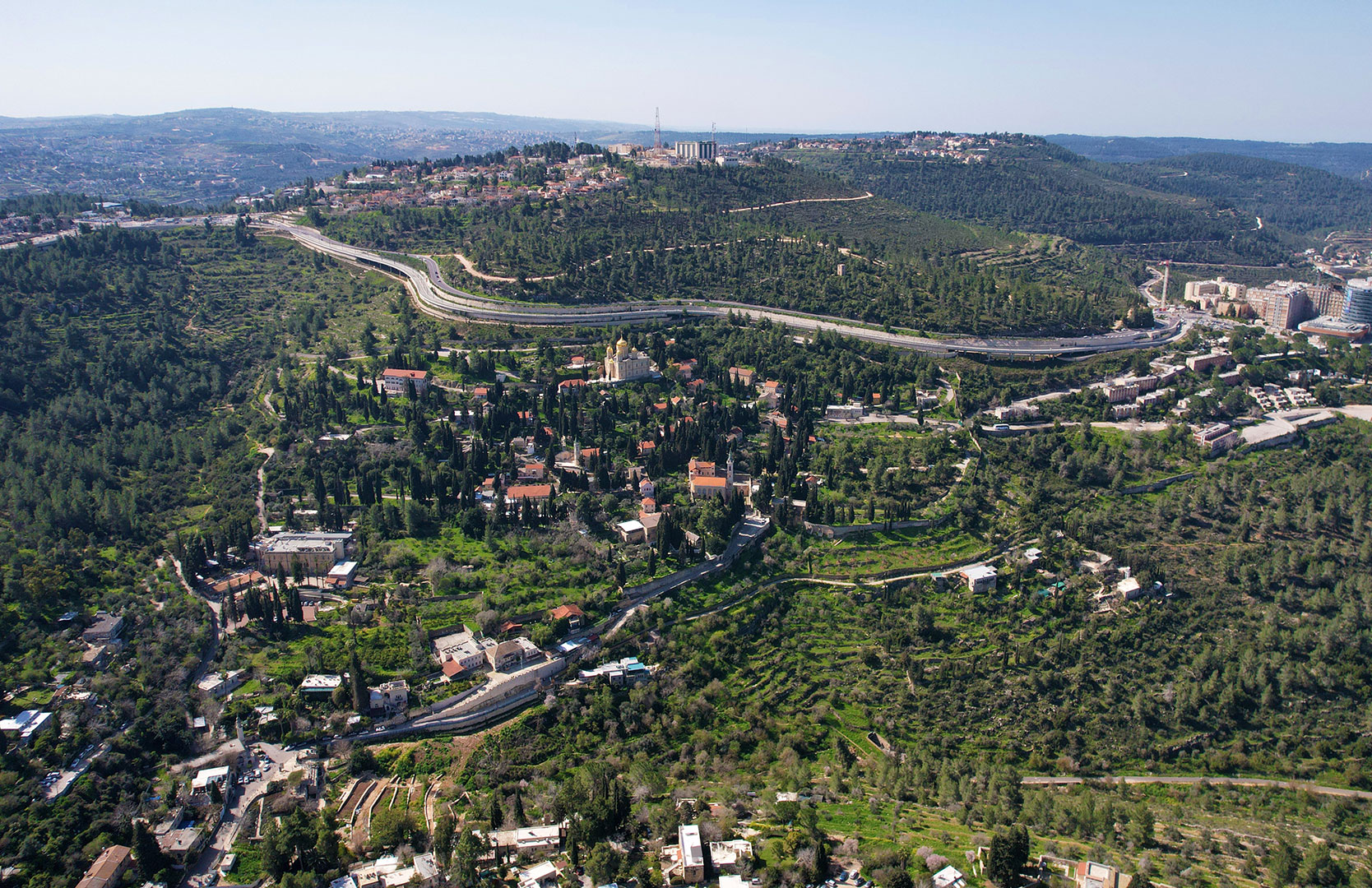
Hadassah Branch, Red Line Light Rail, Jerusalem

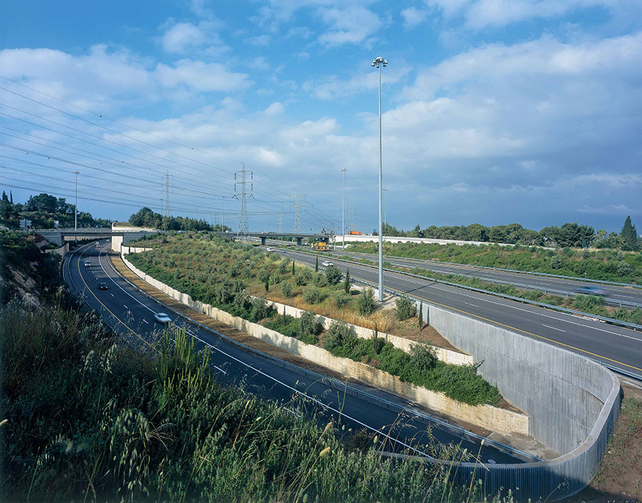
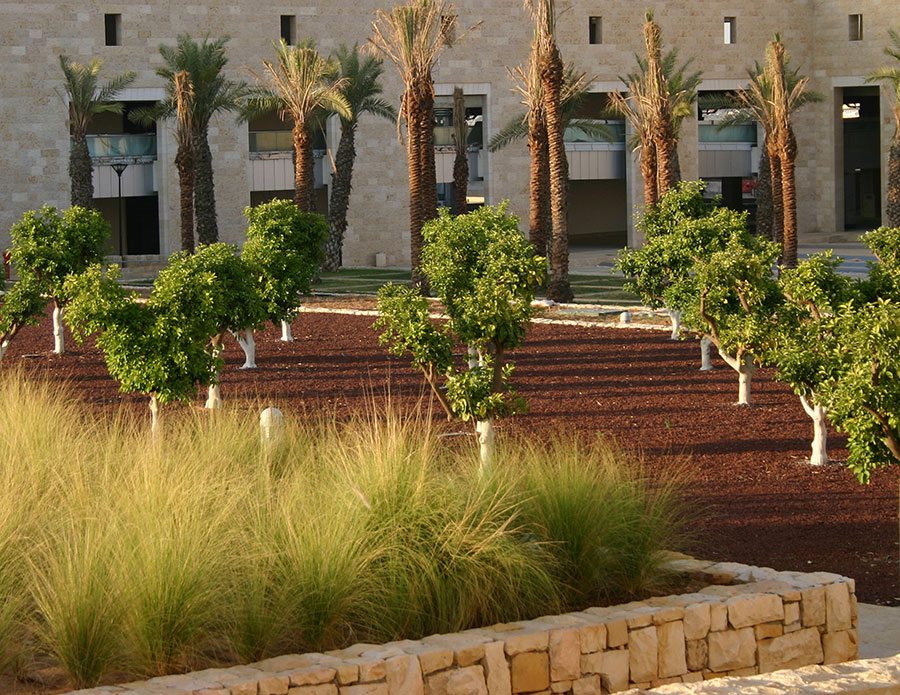
The Hadassah branch of the Red Line completes the southern part of Jerusalem's mass transit system with its extension through the Kiryat HaYovel neighborhood to the Hadassah Ein Kerem Hospital. The statutory planning and subsequent design process proved to be very challenging since the route passes through landscape-sensitive areas on very steep slopes, especially in the section between Ora Junction and the hospital complex. The train travels along one of Jerusalem's most unique ridge lines with spectacular views into its surroundings. Different sections of stepped terrace walls on one or both sides of the train path, in addition to bridges in particularly steep sections, provide architectural solutions for the insertion of the line into the landscape. A promenade which runs below the entire length of the line, provides a new pedestrian and bicycle connection to the hospital, and has become a cherished hiking route for residents of the area. The goal of the landscape scheme was to seamlessly integrate the line into its surroundings by planting native tree, shrubs, perennial and annual plant species. The construction process involved the removal of about 200 existing trees which were successfully transplanted to another nature park. As part of the new plantings, hundreds of new trees, like cypress, olive, pistachio, almond, oak and carob trees were planted together with roughly 120,000 ground cover plants....

Conveyor Belt

In the 1980's, the Dead Sea Works Company, which mines potash from the Dead Sea, began an expansion which would produce a great increase of material needing transportation to the railhead for shipment. This railhead lies eighteen kilometers away (as the bird flies), and eight hundred meters higher in elevation. The company chose to build a conveyor belt; however, since the conveyor belt had to pass through a nature reserve, the Natural Reserve Authority objected. We were asked to arbitrate and to present a new plan acceptable to all parties. Our team rerouted the belt to require the least amount of damaging earthwork. All excavated material had to be taken out of the site, as dumping was not allowed on the flanks of the hills. In order to keep free movement for desert wildlife and hikers, we specified that the belt be supported by a succession of concrete pylons and six more steel bridges than originally proposed. Some of the bridges were lengthened significantly in order not to change the existing topography. Sixteen bridges were constructed and more than a million tons of earth moved over difficult terrain. Yet the lasting damage to the landscape is negligible....

Shaar Hagai Interchange

Halfway between Tel Aviv and Jerusalem at a point where the Judean Hills begin to rise abruptly from the foothills lies the natural gateway to Jerusalem. At this point an interchange was needed to connect the major east-west road between Jerusalem and Tel Aviv with a new major north-south connection. The proposed bridge interchange would have blocked the historical view of the pass through the hills. After much study we proposed sinking the interchange beneath the existing highway a few hundred meters west of the mountain pass, thus preserving unimpeded the historic way up to Jerusalem. The design includes a series of stone terraces beginning at the base of the underpass, which integrate the new intersection into the existing landscape. The interchange is planted with more than a thousand mature olive trees. The newly designed area brings simplicity and order to the interchange, while tying the immense man-made roadwork to its natural surroundings....

Phosphate Works

One of Israel's major mining industries is the exploitation of the phosphates in the Negev Desert.  For decades the Negev Phosphate Works have been removing these materials by open-pit mining. The result has been the creation of a desolate landscape of huge holes with adjacent waste heaps some 40 meters high. Mounting public pressure compelled the company to commission a plan to deal with the ecological and environmental damage caused by its mines. Our strategy called for new mining procedures that eliminate the open pits by refilling them once the phosphates have been removed. The area, slope, and shape of the fill deposits are predetermined in the plan and echo the surrounding crescent-shaped geological formations. The end result is that a new landscape in effect, a gigantic environmental sculpture, is created....

Nesharim Interchange

The challenge of this project was to find a way to integrate a vast and complex infrastructural intervention visually and functionally into the surrounding landscape, minimizing the impact for residents of the adjoining areas, and providing an evocative experience for users of the routes.  The plan thus borrows from both the surrounding agricultural and wild landscapes.  It turns to the existing agricultural landscape for the plantings in the large flat areas which are captured between the roads and ramps.  These areas contain massive groves of carob and olive trees.  Meanwhile, all the slopes are planted with native species of grasses and perennial bushes, and seeded with native annual flowers which are mowed yearly.  In all seasons, the plantings provide a play of colors at a vast scale meant to be understood while traveling at high speeds. The pastoral feel provides a striking contrast to the industrial cement works and ramp bridges, making the Nesharim Interchange a real landmark along the routes which pass through it.  A seasonal river which runs through the interchange is restored with restorative plantings to highlight its course from afar and to augment its ecological value as a wildlife corridor.  All plantings are low-cost and low-maintenance, irrigated with treated wastewater.  Ecological surveys done in recent years show a high biodiversity and indicate that the native plantings have triggered a substantial regeneration of the local flora....

Ben Shemen Interchange

This interchange is one of several that were designed by our office along the historical route between Tel Aviv and Jerusalem. With the insertion of a new lateral north-south highway to Israel, Road#6, the original interchange had to be fully redesigned to accommodate the new road and all its off-ramps. The project is located at the point where the fields of the coastal plain meet the foothills of the Judean Hills. Our overall design concept for the Tel Aviv – Jerusalem highway treats each segment and interchange of the road as part of an ensemble of historical and cultural landscapes and sites, culminating in the arrival to Jerusalem. In the layout of the interchange, preference was given to underpasses instead of bridges in order to ensure visual continuity for the travelers on the major crossroads. In continuation of the existing landscape we created a mosaic of olive and carob tree groves, newly planted forests and agricultural fields in areas where local farmers could tend to them....

Ben Gurion International Airport

Our overall approach to the airport landscape design was to relate strongly to the agricultural landscape of the surroundings: the traditional citrus groves and agricultural fields. The central garden is an abstraction of the natural region with its particular topography and its man-made agricultural development. The design is a clear summary of the physical characteristics of the iconographic landscape from the coastal plain around Tel Aviv up to the mountains of Jerusalem....